For those things that don't fit anywhere else.
What is the location of this photograph by John Kirby Smith?
The mystery location of the "Octagonal Lodges by J. K. Smith of Guiseley" displayed here since 2017, has been solved. Click on his name below for the solution.
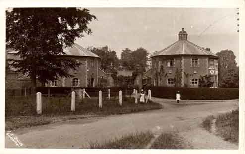
Octagonal Lodges c1906 by John Kirby Smith of Guiseley. Image courtesy of Aireborough Historical Society
How long does it take to survey & build a railway line?
Noticed on the OS 6 inch map of 1851 (surveyed in 1847 to 1848) that the Otley & Ilkley Joint Railway is marked with all the junctions, stations etc. Yet the actual railway didn't open until 1865. We're puzzled by the time difference of 18 years.
Each section of the railway required its own Act of Parliament, would this account for the railway being marked on the map, but not actually existing on the ground? Or did it actually take 18 years to survey & acquire the land & then build it.
If you know the answer contact the webmaster.
Each section of the railway required its own Act of Parliament, would this account for the railway being marked on the map, but not actually existing on the ground? Or did it actually take 18 years to survey & acquire the land & then build it.
If you know the answer contact the webmaster.
Update: Since we posed the question, we've discovered that there were at least x4 attempts to build a railway through Wharfedale before 1847/1848. Two in 1844 and one in 1845 and one in 1846. Each one would have had detailed surveys, mapping & costings done for them.
The 1846 attempt resulted in an Act of Parliament - all the details about the route - land ownership, surveyed line, bridges, cuttings, stations etc were submitted to the authorities. The Ordnance Survey would have received copies.
The issue with the 1846 attempt was that it was a line from Skipton to Arthington. As far as we know it didn't include the link to Menston, Guiseley etc. Also the 1851 map shows the line stopping at Ilkley.
The dating of the 1851 map is clearly wrong and it would be interesting to know what the National Library of Scotland think about this.
Burley Community Library & Burley Archive, Grange Road, Burley in Wharfedale, West Yorkshire England LS29 7HD
Please refer to the Home page for up-to-date opening times. Closed Wednesday & Sunday
Burley Local History & Archive Group: Drop-In Sessions Friday 2.30pm to 4.30pm. For other times please contact us
Burley Local History & Archive Group: Drop-In Sessions Friday 2.30pm to 4.30pm. For other times please contact us
